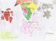
This map shows all the parts of Dreamland that are known yet.Of course there are more lands,but they couldn't be rearranged in a map so easily.
Size
The real size of all regions seen in this map is really big. It is like 3 planets earth put together,but drawn in a piece of paper.
Regions
If you want to see it bigger,click in the map,you'll understand it better...
Digital world
Is somewhere where some hounka creatures,imaginated as a digital creature,computer,computer virus,etc live.
- Media Examples:Digimons,pixcodelics,code lyoko worlds are in
the digital world. Is the yellow area in the map.
????
The water blue area in the map.It was imaginated by someone,some time ago.It is like hollywood here,where people work and entertain in movies.It's not been opened to the whole Dreamland yet,so we dont have so much information about it.(To its creator:did a very nice job)
Naruto world
Its the sweet purple region in the map.Created by the fandom of naruto series,is full of ninjas.find a throwing star there is easier than finding a coin.
Countries
- Wind country at the southwest
- Stone country at northwest
- Rain country at the west of the center.(the 4 sticks)
- Waterfall country at the north (the arrow pointing down)
- Grass country at the center
- Konoha represented by the main symbol of the anime
- Tea country At the south
- Sound village Represented by a musical note
- Thunder country at the northeast
- Wave country an island in the east
- Snow country the last country of the east
Old kosoho
the red area in the map.After a meteor rain crashed most of dreamland,Kosoho blew up in many pieces.Then it was formed the old kosoho republic,which is in war against the factions who throwed the meteors in dreamland.All the islands were named of various american states.
Islands
- Oregon at the center
- tenessee at the southeast
- Florida at the east
- Nevada at the east(the bigger one)
- Ohio at the north
- Rhode Island at the northwest
- California and Idaho at the west
Honoa
The orange region in the map.Its where most of abandoned hounka live.The biggest adoption area of Dreamland.
Size
The honoa that appears in the map is just 1/5 of its size,honoa would need 1 more piece of paper. All because of its population,the goldsun have to imagine more land to all people who live there could fit.the average number of abandoned friends in 1 day is 200.so,every year the population of honoa increases incredibly 700000 people.
Hogwarts
The black land in the map.Made by Harry potter fandom,hogwarts is populated by 80% of witches.Many witches of Dreamland go study there.
[Pokémon world]
The gray land of the map.Created by many poké-maniacs,the pokemon world is where humans and pokemons live peacefully.the pokemon series is passin' through 4 major lands.Their economy turns around pokemon leagues and batles.
GPL countries
- Kanto
- Johto
- Hoenn
- sinnoh
- Nahrta
Another areas
- Chaos island
- Sevii islands
- Snow mountains
- NPW area
Quest kingdom
Swamp-green colored in the map.The area where live many characters of Role playing games.The fans of many RPG series or games imaginated it without knowing.
RS continent
Green colored in the map.It's almost like earth,but with more tribal culture.
Trodain
A wine color represents Trodain in the map.The "dragon quest world" was created by a japanese boy,fan of the series.That's where the characters and monsters of the series can be found.
Unexplored Area
The white part of the map.It's like the USA.A lot of characters where their story is in the USA can be found there.We don't have many information because the secret service block visitors.
????2
Discovered December 25th of 2008.The light green area of the map. A place like greece,with all those historic buildings but with a primitive population.