No edit summary |
|||
| Line 1: | Line 1: | ||
| − | |||
[[Image:Known_imaginary_world.jpg|thumb]] |
[[Image:Known_imaginary_world.jpg|thumb]] |
||
This map shows all the parts of Dreamland that are known yet.Of |
This map shows all the parts of Dreamland that are known yet.Of |
||
| + | course |
||
there are more lands,but they couldn't be rearranged in a map so |
there are more lands,but they couldn't be rearranged in a map so |
||
easily. |
easily. |
||
Revision as of 18:30, 4 January 2009

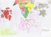
This map shows all the parts of Dreamland that are known yet.Of course there are more lands,but they couldn't be rearranged in a map so easily.
Size
The real size of all regions seen in this map is really big. It is like 3 planets earth put together,but drawn in a piece of paper.
Regions
If you want to see it bigger,click in the map,you'll understand it better...
Digital world
Is somewhere where some hounka creatures,imaginated as a digital creature,computer,computer virus,etc live.
- Media Examples:Digimons,pixcodelics,code lyoko worlds are in
the digital world. Is the yellow area in the map.
????
The water blue area in the map.It was imaginated by someone,some time ago.It is like hollywood here,where people work and entertain in movies.It's not been opened to the whole Dreamland yet,so we dont have so much information about it.(To its creator:did a very nice job)
Naruto world
Its the sweet purple region in the map.Created by the fandom of naruto series,is full of ninjas.find a throwing star there is easier than finding a coin.
Countries
- Wind country at the southwest
- Stone country at northwest
- Rain country at the west of the center.(the 4 sticks)
- Waterfall country at the north (the arrow pointing down)
- Grass country at the center
- Konoha represented by the main symbol of the anime
- Tea country At the south
- Sound village Represented by a musical note
- Thunder country at the northeast
- Wave country an island in the east
- Snow country the last country of the east